South Clarksville, in the Cumberland River bend, is mostly zoned for Montgomery Central High. ZIP 37040 was $304,511 in September 2026, per Zillow.
Last checked Oct. 17, 2026. Sources: the Clarksville-Montgomery County Comprehensive Plan (PDF), South Clarksville planning area; the CMCSS 2026-27 middle and high school zone map (PDF); the Tennessee Department of Education’s 2024-25 A-F letter grade file; the federal NCES school directory; the Zillow Home Value Index (Zillow Research); and OpenStreetMap (© OpenStreetMap contributors).
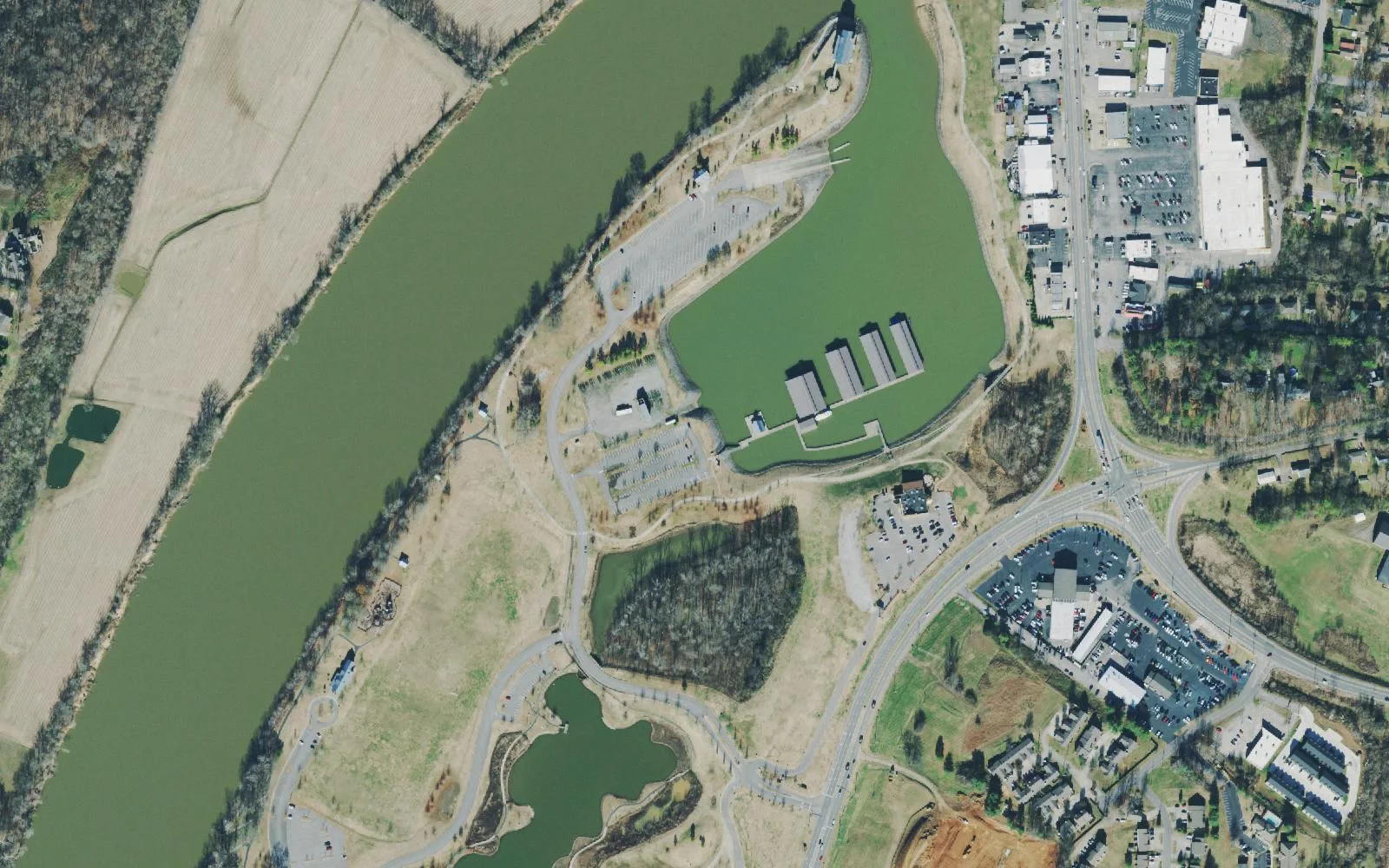
South Clarksville fills the bend of the Cumberland River south of downtown. The county’s Comprehensive Plan describes it as primarily residential, with a pocket of commercial and industrial land on Ashland City Road and stores on Riverside Drive. Much of the river edge is farmed floodplain, and 146 acres of it are Liberty Park and Marina, which the plan calls a success to build on. The plan also points to the Greenwood neighborhood and the streets just south of Ashland City Road as places to invest in existing homes.
What this means for you
- Zoned high school: mostly Montgomery Central High, 3955 Highway 48, Cunningham (2024-25 state letter grade: C).
- Home value: $304,511 in ZIP code 37040 in September 2026, according to the Zillow Home Value Index.
- Nearest I-24 exit: Exit 8 (State Route 237, Rossview Road), about 8 miles away in a straight line.
Part of our Clarksville neighborhoods guide.
Where it is
The plan places South Clarksville in the bend of the Cumberland River, with the Greenwood neighborhood defining its northern edge and the river on the other sides. Riverside Drive, Cumberland Drive and Ashland City Road (State Route 12) are the main roads, and Swift Drive has a planted median the plan wants kept as a demonstration rain garden. Almost all of it is in ZIP code 37040.
The plan’s list for the area:
- Build on Liberty Park and the Marina and connect the Riverwalk trail to Liberty Park
- Redevelop aging big-box retail centers into walkable neighborhood centers, with mixed use along Riverside Drive
- Access management and gateway work on Ashland City Road and Cumberland Drive, and screening between Ashland City Road’s industry and homes
- Pedestrian safety on Riverside Drive and Cumberland Drive
- Preserve Mt. Olive Cemetery and the floodplains, wetlands and steep slopes
- Replace aging and leaky water mains, and fill in older streets with “missing middle” housing where the topography allows
Schools
We read the district’s 2026-27 middle and high school zone map at 41 points across the area. Thirty-five were in the Montgomery Central zone. The other six, in the northeast corner nearest Hilldale, were in the Clarksville High and Richview Middle zone. Grades are from the state’s 2024-25 A-F letter grades:
| Level | School | Address | 2024-25 grade |
|---|---|---|---|
| Middle | Montgomery Central Middle | 3941 Highway 48, Cunningham | B |
| High | Montgomery Central High | 3955 Highway 48, Cunningham | C |
| Middle | Richview Middle (northeast corner) | 2350 Memorial Drive | B |
| High | Clarksville High (northeast corner) | 151 Richview Road | B |
On the state’s components, Montgomery Central High earned an A for achievement, an F for growth and for growth among its lowest-scoring students, and a B for college and career readiness, for an overall C. No zoned elementary school sits inside the area; the district’s K-12 Virtual School is at 1312 Highway 48. Find the elementary zone on the elementary zone map (PDF), check one address in the bus and zoning lookup, and see full results on the Tennessee State Report Card. More in our schools guide.
Home values
Zillow’s typical home value for ZIP code 37040 was $304,511 in September 2026, up 0.6% from $302,676 a year earlier; the city figure was $317,914. The index is a modeled value for a typical mid-priced home, not a sale price, and Zillow does not publish it below the ZIP code level. 37040 also covers downtown and parts of St. Bethlehem and North Clarksville. More in home prices.
Parks and trails
- Liberty Park, 1188 Cumberland Drive: a 10-acre fishing pond, a four-lane boat ramp, a walking trail, a community-built playground, King’s Run Bark Park (membership required), the Wilma Rudolph Event Center and the marina. OpenStreetMap also marks Freedom Point at Liberty Park.
- The plan calls for linking the downtown Cumberland Riverwalk to Liberty Park and for more use of the green space along the river.
More in parks and trails and walking and biking trails.
Getting around
- Main roads: Riverside Drive, Cumberland Drive and Ashland City Road (State Route 12).
- Interstate: I-24 is about 8 miles away in a straight line; Exit 8 (State Route 237, Rossview Road) is closest. Exit names are from OpenStreetMap.
- Distances by road from Liberty Park, measured on OpenStreetMap’s road network: about 2.4 miles to Public Square downtown and about 56 miles to Nashville International Airport. These are distances, not drive times.
- Buses: Clarksville Transit System routes run out from the Transit Center, 200 Legion St.; see the CTS route map for the stops nearest an address.
More in getting around.
Groceries and everyday stores
OpenStreetMap lists no supermarket or pharmacy inside the planning area. The plan’s map marks the Clarksville Shopping Center on Riverside Drive, and the nearest supermarkets on OpenStreetMap are on Madison Street in Hilldale: Kroger, 1489 Madison St., and Publix, 1771 Madison St.
Related: Downtown, Hilldale and property taxes.
Frequently asked questions
Where is South Clarksville?
The county’s Comprehensive Plan puts the South Clarksville planning area in the bend of the Cumberland River, with the Greenwood neighborhood as its northern edge. Riverside Drive, Cumberland Drive and Ashland City Road are its main roads.
What high school is South Clarksville zoned for?
Mostly Montgomery Central High and Montgomery Central Middle on Highway 48 in Cunningham: 35 of the 41 points we read on the district’s 2026-27 zone map. The northeast corner is in the Clarksville High and Richview Middle zone.
Is South Clarksville a good place to live?
Here are the facts. South Clarksville is mostly homes around the 146 acres of Liberty Park and Marina; most of it is zoned for Montgomery Central High, graded C for 2024-25; and the typical home value in ZIP 37040 was $304,511 in September 2026, according to Zillow.
Where is Liberty Park in Clarksville?
At 1188 Cumberland Drive on the Cumberland River in South Clarksville, about 2.4 miles by road from Public Square downtown.
Have your say